|
DESCRIPTION reported
by Johnathan Behr
Mount Pinos (8,831ft.)
is the highest point in the entire Los Padres National Forest,
our state's largest national forest. . Stretching
from Big Sur in the north to Ventura County in the south, the
Los Padres' encompasses a vast amount of public land. Nearly
2,000,000 acres in all! Within it's boundaries, diverse Eco-systems
thrive.
The Los Padres' pristine, wind-swept beaches, wild rivers and
canyons, oak-studded coastal mountains and thickly forested
alpine regions form a microcosm of the beautiful landscapes
California has become known throughout the world for.
At the southern edge of the Los Padres, elevations exceed 8,000
feet near Frazier Park. This is the rooftop of the Los Padres
National Forest. These mountains have been designated the Chumash
Wilderness, and Mount Pinos is considered by the Chumash Tribe
to be the center of their universe. A place of great spiritual
power, where the Gods dwelled.
Indeed,
Mount Pinos is a special place. It is crowned with a rich forest
of white and noble fir, ponderosa and Jeffrey pine, as well
as, lodgepole and limber pine near the summit. The summit itself
is really more of broad undulating plateau that unfortunately
has been marred by the installation of an aeronautical microwave
relay station. Despite this intrusion of man and technology,
you can still have a meaningful wilderness experience on Mount
Pinos.
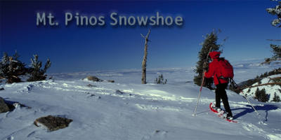
Without
a doubt, the most beautiful time to visit Mount Pinos is after
a series of cold, wet, pacific storms has turned the landscape
into a winter wonderland. Mount Pinos is one of Southern California's
premiere destinations for cross-country skiing and snowshoeing
because of its rolling, open terrain, excellent snow and lovely
views. Add the factor of easy, paved road access to the trailhead
parking lot at 8,300 feet, and you can see why Mount Pinos is
so popular with alpine enthusiasts.
In less
than an hour of snowshoeing, you can be standing on top of a
mountain that is nearly 9,000 feet tall with panoramic views
of the Central Valley, the Southern Sierra, the Tehachipi mountains
and the San Gabriels'. Even the shimmering Pacific and the distant
Channel Islands can be seen on a clear day! This is a great
place to take in the enormity and diversity of the Southern
California landscape. .
THE
TRAIL
Park
your car at the road-end parking lot on the Mount Pinos Rd.
On
your left as you drive into the parking area is the snow-covered
forest service road which winds its way to the summit. Start
out on the road and quickly you will come upon a gate. Continue
past the gate and follow the road to your left. The road will
climb gradually as it snakes through the forest till you reach
a broad plateau. Continue following the well-beaten path across
the open meadow and then your path will climb briefly again
through the trees till you reach another open meadow / plateau.
From here you will see the FAA installation and the true summit
of Mount Pinos. Just keep following the tracks of others before
you. They will lead straight to the summit. Return the way you
came.
|